Kansas Counties Jenkinsgenalogyresearch

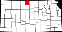
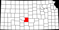
Welcome to  Kansas Genealogy Research

Tracing lives, preserving legacies — one county at a time


Home  |   Contact
                                                                                        
Kansas map of counties

Kansas Orphan Train Riders

Early Days in Kansas published 1927

Military Deaths by county

1950 census images at U.S. National Archives
 When the page is displayed,  click drop down menu to select county

 
Legends of Kansas website... a lot of good info and history


County Created County Seat Location Map
Allen 1855 Iola Map of Allen County
Anderson 1855 Garnett Map of Anderson County
Atchison 1855 Atchison Map of Atchison County
Barber 1867 Medicine Lodge Map
                  of Barber County
Barton 1867 Great Bend Map
                  of Barton County
Bourbon 1855 Fort Scott Map of Bourbon County
Brown 1855 Hiawatha Map
                  of Brown County
Butler 1855 El Dorado Map
                  of Butler County
Chase 1859 Cottonwood Falls Map
                  of Chase County
Chautauqua 1875 Sedan Map of Chautauqua County
Cherokee 1855 Columbus Map of Cherokee County
Cheyenne 1875 Saint Francis Map of Cheyenne County
Clark 1885 Ashland Map
                  of Clark County
Clay 1857 Clay Center Map
                  of Clay County
Cloud 1860 Concordia Map
                  of Cloud County
Coffey 1855 Burlington Map
                  of Coffey County
Comanche 1867 Coldwater Map of Comanche County
Cowley 1867 Winfield Map
                  of Cowley County
Crawford 1867 Girard Map of Crawford County
Decatur 1875 Oberlin Map of Decatur County
Dickinson 1855 Abilene Map of Dickinson County
Doniphan 1855 Troy Map of Doniphan County
Douglas 1855 Lawrence Map of Douglas County
Edwards 1874 Kinsley Map of Edwards County
Elk 1875 Howard Map of
                  Elk County
Ellis 1867 Hays Map
                  of Ellis County
Ellsworth 1867 Ellsworth Map of Ellsworth County
Finney 1883 Garden City Map
                  of Finney County
Ford 1873 Dodge City Map
                  of Ford County
Franklin 1855 Ottawa Map of Franklin County
Geary 1855 Junction City Map
                  of Geary County
Gove 1868 Gove Map
                  of Gove County
Graham 1867 Hill City Map
                  of Graham County
Grant 1873 Ulysses Map
                  of Grant County
Gray 1887 Cimarron Map
                  of Gray County
Greeley 1873 Tribune Map of Greeley County
Greenwood 1855 Eureka Map of Greenwood County
Hamilton 1873 Syracuse Map of Hamilton County
Harper 1867 Anthony Map
                  of Harper County
Harvey 1872 Newton Map
                  of Harvey County
Haskell 1887 Sublette Map of Haskell County
Hodgeman 1879 Jetmore Map of Hodgeman County
Jackson 1855 Holton Map of Jackson County
Jefferson 1855 Oskaloosa Map of Jefferson County
Jewell 1867 Mankato Map
                  of Jewell County
Johnson 1855 Olathe Map of Johnson County
Kearny 1873 Lakin Map
                  of Kearny County
Kingman 1886 Kingman Map of Kingman County
Kiowa 1886 Greensburg Map
                  of Kiowa County
Labette 1867 Oswego Map of Labette County
Lane 1877 Dighton Map
                  of Lane County
Leavenworth 1855 Leavenworth Map of Leavenworth County
Lincoln 1867 Lincoln Map of Lincoln County
Linn 1855 Mound City Map
                  of Linn County
Logan 1881 Oakley Map
                  of Logan County
Lyon 1857 Emporia Map
                  of Lyon County
Marion 1855 Marion Map
                  of Marion County
Marshall 1855 Marysville Map of Marshall County
McPherson 1867 McPherson Map of McPherson County
Meade 1885 Meade Map
                  of Meade County
Miami 1855 Paola
Mitchell 1867 Beloit
Montgomery 1867 Independence Map of Montgomery County
Morris 1855 Council Grove Map
                  of Morris County
Morton 1886 Elkhart Map
                  of Morton County
Neosho 1861 Erie Map
                  of Neosho County
Ness 1867 Ness City Map
                  of Ness County
Norton 1872 Norton Map
                  of Norton County
Osage 1855 Lyndon Map
                  of Osage County
Osborne 1867 Osborne Map of Osborne County
Ottawa 1860 Minneapolis
Pawnee 1867 Larned Map
                  of Pawnee County
Phillips 1867 Phillipsburg Map of Phillips County
Pottawatomie 1857 Westmoreland Map of Pottawatomie County
Pratt 1867 Pratt Map
                  of Pratt County
Rawlins 1873 Atwood Map of Rawlins County
Reno 1867 Hutchinson
Republic 1860 Belleville Map of Republic County
Rice 1867 Lyons Map
                  of Rice County
Riley 1855 Manhattan
Rooks 1867 Stockton Map
                  of Rooks County
Rush 1867 La Crosse Map
                  of Rush County
Russell 1867 Russell Map of Russell County
Saline 1859 Salina
Scott 1873 Scott City Map
                  of Scott County
Sedgwick 1867 Wichita Map of Sedgwick County
Seward 1873 Liberal Map
                  of Seward County
Shawnee 1855 Topeka
Sheridan 1873 Hoxie Map of Sheridan County
Sherman 1886 Goodland Map of Sherman County
Smith 1872 Smith Center Map
                  of Smith County
Stafford 1879 St. John Map of Stafford County
Stanton 1887 Johnson City Map of Stanton County
Stevens 1886 Hugoton Map of Stevens County
Sumner 1867 Wellington Map
                  of Sumner County
Thomas 1885 Colby Map
                  of Thomas County
Trego 1879 WaKeeney Map
                  of Trego County
Wabaunsee 1855 Alma Map of Wabaunsee County
Wallace 1868 Sharon Springs Map of Wallace County
Washington 1857 Washington Map of Washington County
Wichita 1886 Leoti Map of Wichita County
Wilson 1855 Fredonia Map
                  of Wilson County
Woodson 1855 Yates Center Map of Woodson County
Wyandotte 1859 Kansas City

Website built with Copilot AI